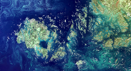
Products based on satellite observations are produced in the Finnish Environment Institute (Syke) in order to monitor environmental changes. These datasets include: surface temperature, algal blooms, water turbidity, CDOM, Secchi depth, chlorophyll-a concentration in the Baltic Sea and the snow-covered area in Finland and the Baltic Sea catchment.
Daily data and season composites are published in the Tarkka service. Products are available on the open Syke web map services. More information, including instructions for Tarkka, can be found Syke EOWiki.

Åland Islands and the Archipelago Sea, 18th August 2015. © Image: Syke. Original data: USGS/NASA Landsat Program. (By clicking on the image, a larger map opens in the Tarkka service.)
Satellite data
Daily products in Tarkka service metadata
-
True color images
(Sentinel-2 MSI, Sentinel-3 OLCI, Landsat-8 OLI, Envisat MERIS) (2002–), metadata
-
Chlorophyll-a in the Baltic Sea
(2003–2011), metadata
-
Turbidity in the Baltic Sea and Finnish lakes
(2011–), metadata
-
Surface algal blooms in the Baltic Sea
(2012–), metadata
-
Surface temperature in the Baltic Sea and Finnish lakes
(2012–), metadata
-
CDOM in the Baltic Sea and Finnish lakes
(2017–)
-
Secchi depth in the Baltic Sea and Finnish lakes
(2016–)
-
Fractional snow cover in the Northern, Eastern and Central Europe
( 2014–), metadata
-
Lake ice extent in Finland in the Baltic Sea catchment area
(2017–), metadata
Composite data in Tarkka service
Disclaimer
Syke is using the Creative Commons By 4.0 International license for open data. This licence applies to Syke's satellite data.
References
Finnish Environment Institute (Syke) / Geoinformatics systems and Geoinformatics research units have produced these Remote Sensing products. Satellite products are based on several NASA, NOAA and EU Copernicus program satellite instruments. Currently Sentinel-2 (ESA), Sentinel-3 (ESA), Landsat-8 (NASA)and TERRA MODIS (NASA) satellites are utilized for monitoring. Previously also NOAA-AVHRR (NOAA), AQUA/TERRA MODIS (NASA), ENVISAT MERIS (ESA), RADARSAT (CSA) and AMSR-E (NASA) were utilized. ENVISAT MERIS and Sentinel-2 images have been downloaded from ESA. Landsat-8 and a subset of the AQUA MODIS images have been downloaded from NASA. NOAA-AVHRR and TERRA / AQUA MODIS images have been received by Finnish Meteorological Institute.
Syke should be cited as a source if data is used in publications or in presentations or made available to the public in some other way. True-color images must be accompanied by an attribution text indicating the original data source. For example, for Sentinel-2 images: "Original images: ESA Copernicus Sentinel Data, Syke" or Landsat-8 images: "Original images: USGS/NASA Landsat Program, Syke". In case of scientific publications which explicitly make use of the products, the appropriate references are to be inquired from the Earth observation team: group@syke.fi [group = eotuki].